By Roberto.Ritossa - 7 Feb 2021
Hello All,
I came through this post
https://www.facebook.com/groups/461762734603032/user/100006372151496
The Seven Seas Cruising Association (SSCA) HF Radio Service Net, FCC Call Sign KPK, is pleased to announce a new service. We have always taken Float Plans of vessels making offshore passages, and tracked them using the HF Radio and/or a satellite GPS tracker such as a Garmin In Reach or Iridium Go.
We now have secured the capability to receive AIS signals from the MarineTraffic satellite feed. This essentially gives us the ability to track any vessel transmitting an AIS signal from most anywhere in the world.
Could OCC be interested in getting the same type of capabilities (access to Sat-AIS data), so that Members' boat positions via Sat-AIS become available when outside coastal stations range?
regards
roberto
|
By simoncurrin - 7 Feb 2021
Roberto
We experimented with MarineTraffic AIS feeds received by satellite 2 years ago but the cost then was prohibitive. Has the price come down dramatically? So yes the OCC would be interested.
When we had a free trial in 2018 it was fantastic to track boats attempting the NW Passage. As you know, there are few MarineTraffic AIS reporting stations in the NWP! AIS B seemed to give reasonably reliable reports via satellite though, of course, class A was more reliable.
Simon
+xHello All, I came through this post https://www.facebook.com/groups/461762734603032/user/100006372151496 The Seven Seas Cruising Association (SSCA) HF Radio Service Net, FCC Call Sign KPK, is pleased to announce a new service. We have always taken Float Plans of vessels making offshore passages, and tracked them using the HF Radio and/or a satellite GPS tracker such as a Garmin In Reach or Iridium Go.We now have secured the capability to receive AIS signals from the MarineTraffic satellite feed. This essentially gives us the ability to track any vessel transmitting an AIS signal from most anywhere in the world.Could OCC be interested in getting the same type of capabilities (access to Sat-AIS data), so that Members' boat positions via Sat-AIS become available when outside coastal stations range? regards roberto
|
By Roberto.Ritossa - 7 Feb 2021
+xRoberto We experimented with MarineTraffic AIS feeds received by satellite 2 years ago but the cost then was prohibitive. Has the price come down dramatically? So yes the OCC would be interested. When we had a free trial in 2018 it was fantastic to track boats attempting the NW Passage. As you know, there are few MarineTraffic AIS reporting stations in the NWP! AIS B seemed to give reasonably reliable reports via satellite though, of course, class A was more reliable. Simon +xHello All, I came through this post https://www.facebook.com/groups/461762734603032/user/100006372151496 The Seven Seas Cruising Association (SSCA) HF Radio Service Net, FCC Call Sign KPK, is pleased to announce a new service. We have always taken Float Plans of vessels making offshore passages, and tracked them using the HF Radio and/or a satellite GPS tracker such as a Garmin In Reach or Iridium Go.We now have secured the capability to receive AIS signals from the MarineTraffic satellite feed. This essentially gives us the ability to track any vessel transmitting an AIS signal from most anywhere in the world.Could OCC be interested in getting the same type of capabilities (access to Sat-AIS data), so that Members' boat positions via Sat-AIS become available when outside coastal stations range? regards roberto
Hello Simon,
thanks for your reply.
I am afraid I have no idea of the costs. I "think" when someone runs a MarineTraffic receiving coastal station he/she has access to (at least some) of their Satellite data. A French MT coastal station has been giving Sat-AIS boats position updates during the recent Vendée Globe race, data were not strictly "real time", sometimes with a 1-2 hour delays but still that could be useful.
If there is anyone here running a MT coastal station might confirm/deny...
Maybe providing MT with say a list of OCC boats MMSIs might be acceptable price wise?
regards
r.
|
By alshaheen - 8 Feb 2021
+x+xRoberto We experimented with MarineTraffic AIS feeds received by satellite 2 years ago but the cost then was prohibitive. Has the price come down dramatically? So yes the OCC would be interested. When we had a free trial in 2018 it was fantastic to track boats attempting the NW Passage. As you know, there are few MarineTraffic AIS reporting stations in the NWP! AIS B seemed to give reasonably reliable reports via satellite though, of course, class A was more reliable. Simon +xHello All, I came through this post https://www.facebook.com/groups/461762734603032/user/100006372151496 The Seven Seas Cruising Association (SSCA) HF Radio Service Net, FCC Call Sign KPK, is pleased to announce a new service. We have always taken Float Plans of vessels making offshore passages, and tracked them using the HF Radio and/or a satellite GPS tracker such as a Garmin In Reach or Iridium Go.We now have secured the capability to receive AIS signals from the MarineTraffic satellite feed. This essentially gives us the ability to track any vessel transmitting an AIS signal from most anywhere in the world.Could OCC be interested in getting the same type of capabilities (access to Sat-AIS data), so that Members' boat positions via Sat-AIS become available when outside coastal stations range? regards roberto Hello Simon, thanks for your reply. I am afraid I have no idea of the costs. I "think" when someone runs a MarineTraffic receiving coastal station he/she has access to (at least some) of their Satellite data. A French MT coastal station has been giving Sat-AIS boats position updates during the recent Vendée Globe race, data were not strictly "real time", sometimes with a 1-2 hour delays but still that could be useful. If there is anyone here running a MT coastal station might confirm/deny... Maybe providing MT with say a list of OCC boats MMSIs might be acceptable price wise? regards r.
|
By alshaheen - 8 Feb 2021
+x+xRoberto We experimented with MarineTraffic AIS feeds received by satellite 2 years ago but the cost then was prohibitive. Has the price come down dramatically? So yes the OCC would be interested. When we had a free trial in 2018 it was fantastic to track boats attempting the NW Passage. As you know, there are few MarineTraffic AIS reporting stations in the NWP! AIS B seemed to give reasonably reliable reports via satellite though, of course, class A was more reliable. Simon +xHello All, I came through this post https://www.facebook.com/groups/461762734603032/user/100006372151496 The Seven Seas Cruising Association (SSCA) HF Radio Service Net, FCC Call Sign KPK, is pleased to announce a new service. We have always taken Float Plans of vessels making offshore passages, and tracked them using the HF Radio and/or a satellite GPS tracker such as a Garmin In Reach or Iridium Go.We now have secured the capability to receive AIS signals from the MarineTraffic satellite feed. This essentially gives us the ability to track any vessel transmitting an AIS signal from most anywhere in the world.Could OCC be interested in getting the same type of capabilities (access to Sat-AIS data), so that Members' boat positions via Sat-AIS become available when outside coastal stations range? regards roberto I recently obtained a quotation fro Marine Traffic for use of the satellite service of $US 212 per month. The service that Glen Tuttle has negotiated apparently only allows the ID of one boat at a time. Hello Simon, thanks for your reply. I am afraid I have no idea of the costs. I "think" when someone runs a MarineTraffic receiving coastal station he/she has access to (at least some) of their Satellite data. A French MT coastal station has been giving Sat-AIS boats position updates during the recent Vendée Globe race, data were not strictly "real time", sometimes with a 1-2 hour delays but still that could be useful. If there is anyone here running a MT coastal station might confirm/deny... Maybe providing MT with say a list of OCC boats MMSIs might be acceptable price wise? regards r.
|
By simoncurrin - 8 Feb 2021
+x+x+xRoberto We experimented with MarineTraffic AIS feeds received by satellite 2 years ago but the cost then was prohibitive. Has the price come down dramatically? So yes the OCC would be interested. When we had a free trial in 2018 it was fantastic to track boats attempting the NW Passage. As you know, there are few MarineTraffic AIS reporting stations in the NWP! AIS B seemed to give reasonably reliable reports via satellite though, of course, class A was more reliable. Simon +xHello All, I came through this post https://www.facebook.com/groups/461762734603032/user/100006372151496 The Seven Seas Cruising Association (SSCA) HF Radio Service Net, FCC Call Sign KPK, is pleased to announce a new service. We have always taken Float Plans of vessels making offshore passages, and tracked them using the HF Radio and/or a satellite GPS tracker such as a Garmin In Reach or Iridium Go.We now have secured the capability to receive AIS signals from the MarineTraffic satellite feed. This essentially gives us the ability to track any vessel transmitting an AIS signal from most anywhere in the world.Could OCC be interested in getting the same type of capabilities (access to Sat-AIS data), so that Members' boat positions via Sat-AIS become available when outside coastal stations range? regards roberto Hello Simon, thanks for your reply. I am afraid I have no idea of the costs. I "think" when someone runs a MarineTraffic receiving coastal station he/she has access to (at least some) of their Satellite data. A French MT coastal station has been giving Sat-AIS boats position updates during the recent Vendée Globe race, data were not strictly "real time", sometimes with a 1-2 hour delays but still that could be useful. If there is anyone here running a MT coastal station might confirm/deny... Maybe providing MT with say a list of OCC boats MMSIs might be acceptable price wise? regards r.
Roberto,
I will check with Peter Dodd's who runs a marinetraffic receiving station in Nova Scotia. Marine Traffic do publish some relayed satellite positions as a teaser but a subscription to a feed is expensive. The last time we looked at upgrading the OCC Fleetmap in this way the cost was in the region of £35,000/year - but that was for the whole fleet.
Simon
|
By Roberto.Ritossa - 8 Feb 2021
Thank you Simon.
£35k... I wonder who would pay such a sum, after all ships can send continuous position updates via satellite, there are a number of free platforms where positions can be displayed in real time.
I was thinking to MT as a lot of people seem to use and like it, I personally use Winlink and appear on MT displays only when in their coastal receiving stations range.
r.
|
By simoncurrin - 8 Feb 2021
+xThank you Simon. £35k... I wonder who would pay such a sum, after all ships can send continuous position updates via satellite, there are a number of free platforms where positions can be displayed in real time. I was thinking to MT as a lot of people seem to use and like it, I personally use Winlink and appear on MT displays only when in their coastal receiving stations range. r.
Roberto
Just to avoid confusion- that was to the whole OCC Fleet of 1,000 boats. Using the terrestrial feeds to our website's OCC Fleet map is actually incredibly cheap - I think <£1/year per boat.
Simon
|
By alshaheen - 9 Feb 2021
+xThank you Simon. £35k... I wonder who would pay such a sum, after all ships can send continuous position updates via satellite, there are a number of free platforms where positions can be displayed in real time. I was thinking to MT as a lot of people seem to use and like it, I personally use Winlink and appear on MT displays only when in their coastal receiving stations range. r.
Hi Roberto
Apologies for the blank replies above but it seems that replying to a post using my iPad is impossible. Now using a laptop. Just one of the many frustrations of using this Forum.
I just wanted to report that I was recently in correspondence with Marine Traffic about using their satellite tracking service to track small craft (leisure vessels) in the Indian Ocean and they quoted me US$ 212 per month.
The link you started this train with was made by Glen Tuttle of Boatwatch. Glen recently advised me that the concessionary service he has negotiated with MT allows him to track only one boat at a time.
|
By Roberto.Ritossa - 9 Feb 2021
Hello John,
thanks a lot, so probably Boatwatch has the capability to follow through Sat-AIS "the" boat which needs to be watched, for whatever reason she is being officially watched (distress, accident underway, etc).
Indeed not a viable option for a large-ish fleet.
Regards
r.
|
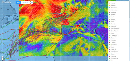
By DariaBlackwell - 13 Mar 2021
Last year we tracked more than 100 vessels across the Atlantic using PredictWind's new tracker. George Curtis will be exploring using the service for our expanded cruising resources. It means setting up a second fleet but we have a lot of experience documented already on how to do it. Stay tuned.
|
By alshaheen - 15 Mar 2021
+xLast year we tracked more than 100 vessels across the Atlantic using PredictWind's new tracker. George Curtis will be exploring using the service for our expanded cruising resources. It means setting up a second fleet but we have a lot of experience documented already on how to do it. Stay tuned.
How does this work Daria? Presumably it relies on all boats using Predict Wind? Do they have to manually input and report position data?
|
By DariaBlackwell - 15 Mar 2021
+x+xLast year we tracked more than 100 vessels across the Atlantic using PredictWind's new tracker. George Curtis will be exploring using the service for our expanded cruising resources. It means setting up a second fleet but we have a lot of experience documented already on how to do it. Stay tuned. How does this work Daria? Presumably it relies on all boats using Predict Wind? Do they have to manually input and report position data?
Hi John,
One does not need a subscription if they set it up for us as an organisation, which they did last year for free. You only get use of the tracker, not the very effective weather routing, without a subscription. The feed is automatic from a number of different sources, including IridiumGo, and can be done via SMS or email via SAT phone once set up properly. Alex wrote it all up after the Atlantic Crossing last year. He also maintained extensive 'how to' notes on each system. https://liveicomgrshot.blob.core.windows.net/occfiles/ffarticles/70_alex%20blackwell%20ff.pdf
Daria
|
|