By Dick - 26 Oct 2023
Hi all,
We did not use Ocean Pilot Charts all that much for fundamental guidance, but they did get referred to before any ocean passage and were fun to have aboard for the occasional answering of questions that inevitably come up among sailors sharing a beer. And there is a wealth of data in those charts in addition to expected wind speeds/directions on a monthly chart.
Jimmy Cornell has done his own and they can be found at: Paradise Cay Publishing in the revised and updated edition of the "Cornell’s Ocean Atlas, Pilot Charts for all Oceans of the World". That, and his updated “Routes” book deserve a place on any widely wandering boat.
My best, Dick Stevenson, s/v Alchemy
|
By bweigel2@gmail.com - 26 Oct 2023
Hello Dick,
I agree that pilot charts are a good resource. I found them available online for free and can be displayed with OpenCPN. If I can find a link I will add it to this post.
Thanks
Bill W
|
By Dick - 26 Oct 2023
+xHello Dick,I agree that pilot charts are a good resource. I found them available online for free and can be displayed with OpenCPN. If I can find a link I will add it to this post. ThanksBill W
Hi Bill,
Good info that the charts are on-line. I suspect the ones on-line are the traditional pilot charts accumulated over decades: centuries even. I have no comparison, but the Cornell charts are described as reflecting current conditions, but I have not researched enough to ascertain how different our current “average” conditions are from the averages generated over centuries.
I have heard that his “routes” book reflects the “anomalies” that are occurring with greater frequency and that he has shifted, for example, the dates when one is most assured of a hurricane free trip from the East Coast of the US to Bermuda or, to put another way: expanded the period where hurricanes might occur.
If you find a review of either the book or the new charts, please post.
My best, Dick
|
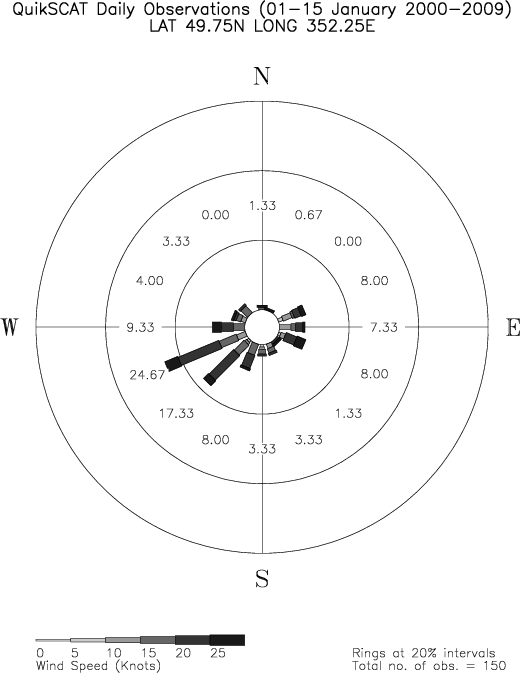
By Roberto.Ritossa - 10 Nov 2023
Hello,
that data is very likely to be a compilation of COGOW data:
http://cioss.ceoas.oregonstate.edu/cogow/index.html
it reflects wind statistics taken from scatterometer satellite, QuickScat at the time (it has been replaced since).
Just choose the bi-weekly period of the year and click on the map, Wind data is more detailed than usual Pilot Charts, and is available in original observation counts, tabular form or graphical form, example
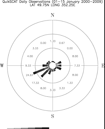
regards, r.
|
|